Posts
46 posts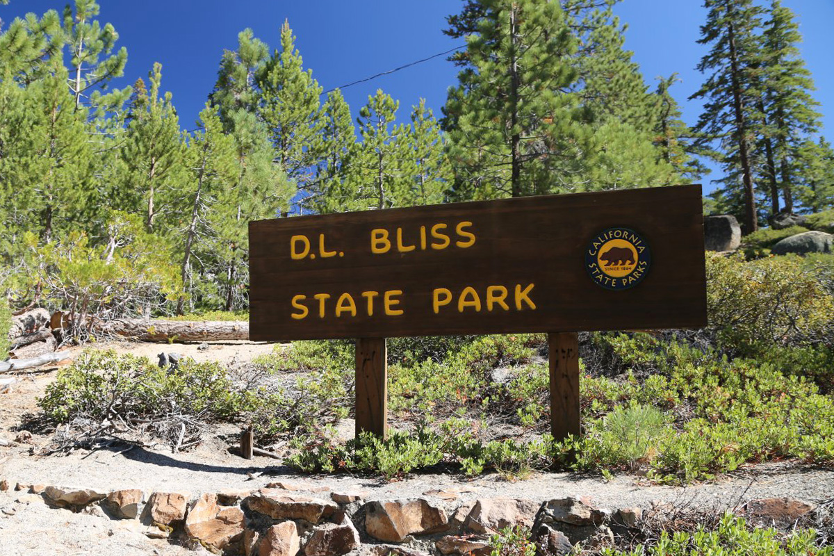
루비콘(Rubicon) 트레일과 레스터(Lester) 비치가 유명한 레이크타호 블리스(D. L. Bliss) 주립공원
사실 이번 여행이 위기주부와 아내에게 레이크타호(Lake Tahoe)의 첫번째 방문은 아니었다. 본인은 학회로 와서 친구 렌트카를 타고 정말 잠시 들렀었고, 아내도 출장와서 주말에 잠시 여행한 적이 있었다. 하지만 둘 다 기억도 가물가물한 까마득한(?) 옛날 이야기이다~ 에머랄드베이 주립공원을 떠나서 바로 위에 붙어있는 DL블리스 주립공원(D. L. Bliss State Park)에 도착을 했다. 이 땅을 캘리포니아 주에 기증한 Duane Leroy Bliss의 이름을 딴 공원이라고 하는데, 왜 그냥 Bliss 또는 Duane Bliss가 아니고, 공식적으로 'D. L. Bliss'로 이름을 지었는지 궁금하다. 89번 도로에서 공원으로 들어가는 진입로가 여럿 있고, 또 네비게이션이 북쪽 출입구로 들어가라고 나오는 경우도 있지만, 여기 제일 남쪽을 제외하고는 일반차량은 들어갈 수 없는 길이다. 직원이 있는 게이트를 통과한 후, 울창한 소나무숲 속의 좁은 도로를 따라 여러 캠핑장을 지나서 끝까지 달리면 루비콘트레일(Rubicon Trail)의 출발점이 나온다. 타호 호숫가를 따라서 에머랄드베이(Emerald Bay) 주립공원의 이글포인트(Eagle Point)까지 편도 7.4마일의 산책로는 캘리포니아 최고의 트레일들 중의 하나로 항상 손꼽힌다. "자~ 그럼 우리도 루비콘트레일을 출발해볼까?" (구글맵으로 위치를 보시려면 클릭) 정말 오래간만에 보는 맑은 청록색의 물색깔! 트레일을 벗어나 오른편에 살짝 보이는 바위쪽으로 나가보았다. 주차장에서 반대쪽으로 내려가면 나오는 모래사장이 호숫가를 따라서 쭉 이어진 것이 보인다. 약간 위험하기는 했지만 바위절벽의 끝으로 지혜와 둘이서 좀 더 올라가보기로 했다. 루비콘포인트(Rubicon Point) 끝에 선 우리집 '재택공부' 대학생... 보스턴에는 언제 다시 돌아갈 수 있으려나? 아내가 앉아서 기다리던 벤치에 앉아서 함께 레이크타호를 바라본다. 트레일을 따라서 500미터 정도 더 걸어가면 세계에서 가장 높은 곳에 만들어진 등대라는 'Old Lighthouse'가 나온다고 해서, 거기까지만 가보는 것이 가이드의 계획이었기는 했지만... 그냥 발길을 돌려 저 호숫가 레스터비치(Lester Beach)로 내려가서 물에 발이라도 한 번 담궈보기로 했다. 이렇게 말이다~^^ 물속에서 걸음을 옮길 때마다 발가락 사이로 모래가 비집고 올라오는 느낌이 정말 오래간만이었다. 8월말 월요일이었는데 저 멀리까지 제법 많은 사람들이 여기 해발 2천미터에 가까운 산정호수에서 시간을 보내고 있었다. 모터보트, 패들보드, 카누, 튜브, 그리고 산불연기 때문에 저 멀리 뿌옇게 보이는 네바다 주의 산들... 이렇게 레이크타호 두번째 주립공원 구경을 마치고 모래가 묻은 발에 샌달을 신고 다시 호숫가를 따라서 북쪽으로 달렸다. 블리스 주립공원을 나와서 캘리포니아 89번 주도(California State Route 89)를 따라서 호숫가 피크닉 장소까지 영상을 4배속으로 편집한 것을 보실 수 있다. 키 큰 소나무들 사이로 멋진 통나무 집들과 작은 마을을 지나면서, 간간이 호수도 오른편으로 보이는 멋진 드라이브코스였다. 아내가 인터넷으로 찾은 카스피안 캠핑장(Kaspian Campground) 건너편의 피크닉테이블에 자리를 잡았는데, 자전거 전용도로는 많이 봤어도 '자전거 캠핑장'은 미국에서도 처음 보는 것 같았다. 컵밥과 커피믹스로 점심을 먹고는 타호시티(Tahoe City)까지 북쪽으로 호숫가를 또 달린 후에, 호숫물이 흘러나가는 트러키 강(Truckee River)을 따라서 동계올림픽이 열렸던 올림픽밸리(Olympic Valley) 스키장 입구를 지나, 80번 인터스테이트 고속도로와 만나는 곳에 있는 이 날의 세번째 주립공원 목적지를 찾아갔다. 아래 배너를 클릭해서 위기주부의 유튜브 구독하기를 눌러주시면 정말 감사하겠습니다.^^
캘리포니아에 화산이 있다! 래슨볼캐닉(Lassen Volcanic) 국립공원 범패스헬(Bumpass Hell) 트레일
캐나다에서 시작해 워싱턴, 오레곤을 지나 북부 캘리포니아에서 끝나는 길이 1,100 km의 캐스케이드 산맥(Cascade Range)은 태평양을 감싸는 '불의 고리(Ring of Fire)'의 일부로 레이니어(Rainier), 세인트헬렌스(St. Helens) 등의 화산이 많은데, 이 산맥 가장 남쪽의 캘리포니아에 속한 화산지역이 래슨볼캐닉 내셔널파크(Lassen Volcanic National Park)로 1916년에 미국의 11번째 국립공원으로 지정이 되었다. 9박10일 자동차 캠핑여행의 4일째인 화요일, 해발 2,040 m의 서밋레이크노스(Summit Lake North) 캠핑장에 아침해가 떠올랐다. 누룽지를 끓여 아침으로 먹고는 이 국립공원에서 가장 인기있는, 그래서 일찍 안가면 주차장에 빈 자리가 없다는 범패스헬 트레일(Bumpass Hell Trail)을 하러갔다. 전편에서 소개한 이 국립공원 간판을 보면 점선으로 그려진 산이 있는데 (보시려면 클릭), 약 40만년 전까지는 왼편에 보이는 Diamond Peak의 위쪽으로 1 km 이상을 더 솟아있던 화산인 마운트테하마(Mount Tehama)가 있었다고 한다. 그런데 모두 침식으로 깍여서 사라지고 남은 가장자리가 오른쪽에 멀리 보이는 바위절벽의 브로크오프산(Brokeoff Mountain)이라고 한다. 범패스헬 트레일을 시작하는 곳은 주차장의 동쪽 끝에 있었는데, 마스크를 쓴 모녀의 뒤로 이 국립공원에서 제일 높은 봉우리인 해발 3,187 m의 래슨피크(Lassen Peak)가 보인다. 브로크오프 산을 배경으로 우리 차를 세워둔 주차장을 줌으로 당겨봤는데, 코로나에 산불까지 겹쳐서 주차장이 한산했다. 철이 좀 지난 듯 했지만, 나지막한 보라색 루핀(Lupine) 꽃을 보니까 우리가 북쪽으로 많이 올라왔다는 생각이 들었다. 그렇게 천천히 30분 정도 평탄한 트레일을 걷다보면 바람에 실려온 유황냄새를 먼저 코로 느낀 후에, 나무 사이로 이런 풍경이 보이면 '범패스의 지옥(Bumpass's Hell)'에 도착을 한 것이다. 1864년에 Kendall Vanhook Bumpass가 이 곳을 처음 발견해서 직접 관광지로 개발을 하려다가, 땅이 꺼지면서 펄펄 끓는 진흙에 빠져 한 쪽 다리를 잃었다고 한다. 역시 지옥(Hell)이 땅 아래에 있다고 생각하는 것은 동서양이 같은 듯... 안내판을 지나 길이 두개로 갈라지는데, 당연히 우리는 더 가까이 보면서 내려갈 수 있는 왼편으로 선택했다. 곳곳에서 연기가 피어오르는 이 분지는 래슨볼캐닉 국립공원에서 가장 넓은 열수지역(hydrothermal area)으로 소위 '캘리포니아의 옐로우스톤'이라 불리는 곳이다. (구글맵으로 위치를 보시려면 여기를 클릭) 왼편의 뜨거운 풀(pool)과 마스크의 색깔이 거의 똑같은 듯...^^ 모자에 부착하고 찍은 액션캠 동영상은 마지막에 보여드린다. 작년 9월에 완전히 새로 만들었다는 보드워크를 따라서 연기가 많이 보이는 끝까지 걸어가본다. 제일 큰 진흙호수까지 왔는데 여기는 펄펄 끓고있지는 않았다. 왜냐하면 멀리서 보이던 연기는 왼편 언덕너머에서 나는 것이었는데, 여기서는 가려서 보이지 않았다. 그래서 반대편 언덕에 있다는 전망대까지 계속 올라가봤다. 계속 오전의 역광이었는데, 여기 반대쪽에 전망대에 오니까 파란 하늘아래 사진이 잘 나와서 올라온 보람이 있었다. 조금 전에 걸었던 보드워크와 큰 진흙호수가 가운데 보이고, 그 오른편 아래로 언덕을 사이에 두고... 부글부글 끓고있는 머드팟(mudpot)이 있었다! 옐로스톤 국립공원을 두 번이나 방문했었지만, 그래도 또 봐도 신기하다.^^ 모녀가 전망대의 노란 바위를 하나씩 차지하고 앉아서 쉬고 있다. 여기서 동쪽으로 계속 걸어가면 Cold Boiling Lake가 나온다고 하는데 너무 멀어서 주차장으로 돌아가기로 했다. 먼저 내려간 지혜와 엄마를 멀리서 찍어주고는, 위기주부는 개울 건너편의 산책로를 따라서 내려갔다. 보드워크 아래로 흐르는 진흙개울을 보면서, 좀 떠다가 천연유황 머드팩을 하면 좋겠다는 말씀을 하셨다. 주차장에서 출발해서 범패스헬을 둘러본 영상을 클릭해서 보실 수가 있다. 사진으로는 보여드리지 못하는 연기가 피어오르는 모습과 함께, 바람소리가 거슬리기는 하지만 자세히 들어보면 부글부글 끓는 소리도 좀 들린다. 유황냄새까지도 기록하고 전달을 해드릴 수 있으면 좋으련만...^^ 절벽 끝에서 왜 개구리 포즈를? 주차장 거의 다 돌아가서 도로옆 언덕으로 올라가면 이렇게 레이크헬렌(Lake Helen)에 비친 래슨피크를 볼 수가 있다. 여기서 아내와 지혜는 바로 도로로 내려가 호숫가에서 기다리고, 위기주부만 주차장까지 더 걸어가서 차를 가지고 픽업을 했다. 헬렌 호숫가에서 사모님은 스마트폰을 보시고, 지혜는 래슨 봉우리를 바라고보 있다. "지혜야, 우리 저기 올라가보지 않을래?" P.S. 한국은 추석연휴가 시작되었네요~ 연휴에 고향 가시고 또 미국여행 계획하셨던 분들도 계셨을 텐데, 올해는 코로나 때문에 모든 것이 예년과는 다른 상황입니다만, 그래도 어디에 계시던지 모두 건강하고 즐거운 연휴 보내시기를 바랍니다.^^ 아래 배너를 클릭해서 위기주부의 유튜브 구독하기를 눌러주시면 정말 감사하겠습니다.^^
소셜디스턴싱(Social Distancing) 위한 행잉락(Hanging Rock) 트레일과 라지폴(Lodgepole) 캠핑장
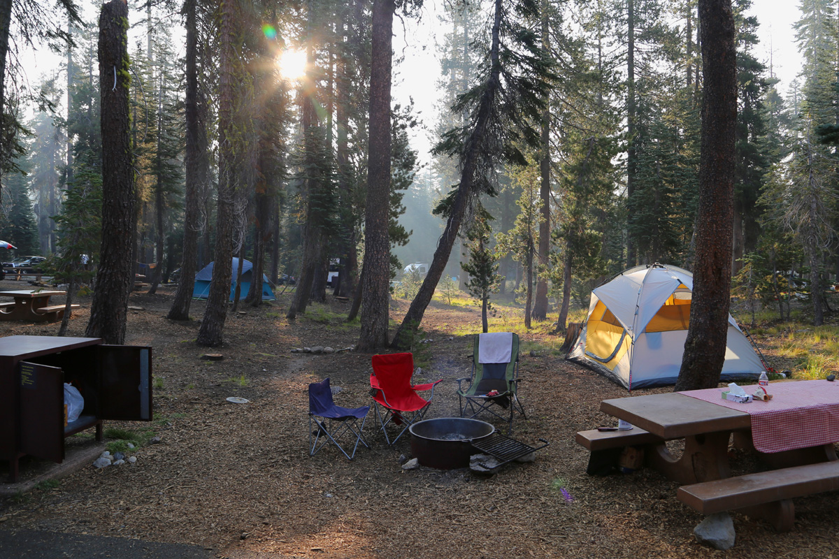
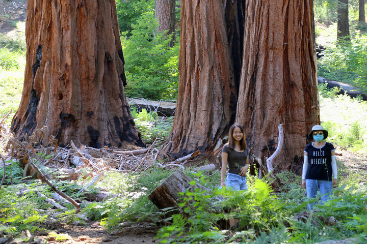
요즘은 미국이나 한국이나 소셜디스턴싱(Social Distancing), '사회적 거리두기'라는 말이 항상 들린다. 얼마 전에 소셜디스턴싱하기 좋은 미국 국립공원 트레일 5개를 소개한 여행기사를 읽으면서, 세쿼이아 국립공원에 이런 트레일이 있다는 것을 위기주부도 처음 알았으니까, 그 만큼 썰렁하고 인기없는 트레일이라는 뜻이다.^^초생달 초원을 구경하고 Crescent Meadow Rd를 돌아 나오면서 바로 그 썰렁한 트레일이 시작되는 곳에 들렀다. 처음에 안내판을 HANG'NG은 왼쪽으로 1마일, ROCK MUSEUM은 오른쪽으로 1.3마일로 잘못 읽었는데, 우리의 목적지인 행잉락(Hanging Rock)은 왼쪽으로 0.1마일 이었다. (자기가 잘못 보고 뭐라해놓고는 치사하게 점을 손가락으로 가리고 있음)키 큰 세쿼이아 나무들을 돌아서, 그 뒤로 보이는 언덕까지만 올라가면 딱 0.1마일, 그러니까 160m 정도 될 것 같았다.거대한 세쿼이아 나무들은 정말 보고 또 봐도 신기하고 이쁘다.5분만에 트레일 끝! (구글맵으로 이 바위가 어디에 있는 것인지 위치를 보시려면 클릭)"뭐야~ 행잉락(Hanging Rock)이면 줄에 매달려있어야 하는 것 아니야?" 절벽끝에 아슬아슬하게 걸쳐져있는 것도 영어로 '행잉(hanging)'이라고 부르는가 보다~ 이 사진에서는 얼핏 별로 커보이지 않지만...바위 바로 옆까지 조심해서 경사를 내려가보면 이렇게 제법 큰 바위이다. ※주의! 바위 뒤쪽으로는 난간도 전혀 없이 바로 절벽이므로, 혹시 이 글을 보시고 찾아가는 분이 계시면 조심하시기 바랍니다.잘 매달려 있는지 둘이서 힘껏 밀어보는 중... 조금도 움직이지는 않았지만, 여기서 한국사람이면 누구나 딱 떠오르는 이름이 있어서 앞으로는 '세쿼이아 흔들바위'로 부르기로 했다. 그런데 나름 절벽 가장자리에 아슬아슬한 바위도 멋있고 전망도 훌륭한 이 곳이 이토록 썰렁한 이유는 여기서 왼편으로 고개를 돌리면 알 수 있다.가운데 둥글게 솟아있는 바위가 세쿼이아 국립공원에서 가장 유명한 전망대 바위인 모로락(Moro Rock)이다. 평상시는 셔틀버스를 타야만 들어올 수 있는 이 도로에서 정류소가 저 모로락 트레일헤드에만 있으니, 여기 행잉락은 거의 알려지지 않은 이유가 충분했다. 모로락은 이미 4번이나 올라가봤기 때문에 (여행기는 여기를 클릭), 직접 차를 몰고 들어올 수 있는 김에 일부러 여기를 찾아온 것이고,무엇보다도 확대사진에 보이는 모로락은 바위를 깍아서 만든 올라가는 길이 아주 좁아서 거의 사람들과 부딪히며 걸어야 하고, 또 난간을 손으로 잡아야 하는 등 도저히 '소셜디스턴싱(Social Distancing)'을 하는 것이 불가능한 트레일이기 때문이었다.반면에 여기는 우리가 트레일 시작할 때 근처 바위 꼭대기에 커플이 잠시 보였던 것을 제외하면, 다시 차로 돌아갈 때까지 다른 사람은 아무도 마주치지 않은 완벽한 사회적 거리두기가 가능했던 트레일이다. 가이드가 뿌듯한 마음으로 여행 첫날 트레일 일정을 모두 마치고, 이제 캠핑장으로 출발~^^자동차 블랙박스 영상을 캡쳐한 사진에는 라지폴(Lodgepole) 캠핑장의 입구에 "Campground Full, All Sites Reserved"라고 안내판을 세워 놓았지만... 사실 저건 거짓말이다~ 일단 우리는 예약사이트 번호와 이름을 알려주고 안으로 들어가서 자리를 잡았다.저녁을 해먹기 전에 시간이 남아서 계곡을 건너 내일 아침에 할 트레일이 시작되는 곳으로 와보니, 코비드19(COVID-19) 관련 안내문이 있었다. 만약 이 장소가 붐비면 근처에 다른 하이킹을 하라고, 또 사람이 많은 전망대와 주차장은 피하라고 되어있는데, 처음 이 국립공원에 와서 유명한 곳들을 구경하려는 사람들에게 그게 가능할까? 물론 이번이 8번째 방문인 우리집이야 가능하지만...^^갈비를 구워서 저녁을 맛있게 먹고는 잘 준비를 하려고 화장실을 다녀오는 길인데, 캠핑장이 예약이 모두 차서 풀(full)이라고 입구에 써있었지만 어두워지는 주차장이 아주 한산하다.그 이유는 바로 코비드19 때문에 이 라지폴 캠핑장의 전체 214개 사이트 중에서 1/3 정도만 6월말부터 예약을 다시 받았고, 나머지 사이트는 이렇게 손님을 받지 않고있기 때문이다. 캠프사이트간의 거리로만 본다면 원래 많이 떨어져 있기 때문에, 모든 사이트의 예약을 받아도 소셜디스턴싱이 충분하지만, 전체 국립공원의 이용객 수를 최대한 줄이기 위해서 이렇게 안타깝게 운영을 하고 있는 것이다.어김없이 우리는 또 불을 지르고, 해발 2,050m에 위치한 라지폴 캠핑장의 밤하늘이 푸르고 맑게 어두워지고 있다.지난번 캠핑에서 별사진을 너무 못 찍어서 다시 알아봤더니, ISO만 무조건 최대로 올리는게 아니라 ISO는 3200 정도로만 하고 조리개를 최대한 여는 것이 중요했다. 삼각대는 없었기 때문에 피크닉테이블 위에 카메라를 하늘로 향하게 그냥 놓고 30초 노출로 찍은 사진이다.마스크를 쓰고 소셜디스턴싱(Social Distancing)을 해야 하는 인간들을 비웃기라도 하듯이, 캠핑장 밤하늘에 수 많은 별들이 아무 거리낌없이 다닥다닥 붙어있는 사이로 별똥별 하나가 지나가고 있었다.
놀라운 풍경과 지형으로 미서부에서 절대 놓칠 수 없는 42개의 하이킹 코스
미서부 여행잡지인 선셋(Sunset)에서 <42 Can’t-Miss Hikes in the West for Amazing Scenery and Terrain>라는 제목의 기사를 보고, 그 중에 위기주부는 몇 개의 하이킹 코스를 가보았는지 확인해보는 김에 블로그에도 소개해드린다. 각 트레일 설명까지 번역하기에는 일이 너무 많아서 원문을 그대로 보여드리는데, 각 트레일명이 빨간색으로 링크된 것은 클릭하면 위기주부가 그 곳을 다녀온 네이버 블로그의 포스팅을 보실 수 있으며, 그 다음 지역이나 공원명에 링크가 되어 있으면 트레일은 하지 않았지만 그 '근처'에는 가봤다는 뜻임을 미리 알려드린다.1 of 42 Dave LauridsenLa Quinta Cove, La Quinta, CADifficulty: EasyDistance: 3.6 miles (round-trip)Elevation Gain: 360 feetCoachella Valley is home to the Santa Rosa Mountains, where granite, desert flora, and sweeping views surround primo hiking. And La Quinta, 25 miles southeast of Palm Springs, is a great entryway for hikers: Take the Cove to Lake Trail, a 2.5-mile one-way trek. Or, for serious burn, consider the strenuous 7.5-mile Boo Hoff Trail. Afterward, crash at one of these super-stylish hotels.2 of 42 Thomas J. StoryDelicate Arch Trail, Arches National Park, UTDifficulty: EasyDistance: 3.1 miles (round-trip)Elevation Gain: 613 feetThe geologic fantasyland of Arches has some of the best hikes in the country, webs of trails with mind-blowing views. But don’t miss the easy 3-mile round-tripper to the park’s most iconic landmark, Delicate Arch. From the trailhead at Wolfe’s Ranch, follow the route past Ute petroglyphs onto waves of swelling sandstone where the freestanding arch rears up to defy gravity. Time your trek during the magical twilight hour—you won’t be alone, but you will see a spectacle some 70,000 years in the making ignited in the crimson colors of the sunset.3 of 42 James Randklev/GettyHall of Mosses Trail, Hoh Rain Forest, Olympic National Park, WADifficulty: EasyDistance: 1 mile (round-trip)Elevation Gain: 78 feetSee a rich spectrum of greens: the deep emerald of licorice fern, the wan olive of hanging club moss, and the turqoise of Sitka spruce needles. One of the best ways to see this verdant brilliance is the Hall of Mosses Trail by the Hoh Rain Forest Visitor Center. The rainforest is one of the most jaw-dropping beautiful things you have to see in the park. Bring shoes that can get muddy and don't be discouraged if it's raining—the forest is magical under any conditions.4 of 42 David FentonGrizzly Falls, Kings Canyon National Park, CADifficulty: EasyDistance: 0.1 miles (round-trip)Elevation Gain: 19 feetSome of the best hikes are waterfall hikes. Head off Kings Canyon Scenic Byway and hike the short, easy trail up to the impressive Grizzly Falls. The 75-foot waterfall is at its best in spring, when the thunderous force is so strong you can feel the reverberations in your chest. Best part is: you barely have to do anything to get to this amazing view. It's one of the best hikes to do when you're camping at the park with kids.5 of 42 Getty Images / Ezra ShawTennessee Valley Trail, Marin Headlands, Sausalito, CADifficulty: EasyDistance: 3.4 miles (round-trip)Elevation gain: 170 feetJust across the Golden Gate Bridge from San Francisco, the Marin Headlands offer shoreline views, crashing surf, and a surprising wildness. Join the parade of cars winding up twisty Conzelman Road to Hawk Hill, but don’t stop there. The Tennessee Valley Trail winds 2.2 miles (one way) past rolling hills toward a secluded beach awash with green and black basalt pebbles.6 of 42 Matthew Micah Wright/GettyRed Rock Trail, Whiting Ranch Wilderness Park, Foothill Ranch, CADifficulty: EasyDistance: 4.2 miles (round-trip)Elevation Gain: 470 feetThe 2,500 acres of oak woodland canyons and grassland hills in Whiting Ranch Wilderness Park are filled with flowers like phacelia, lupines, mariposa lily, canyon pea, and wild rose blooming from about March through May. Bonus: stunning rock formations along Red Rock Trail (4.5-mile round-trip). Bring the family, and expect to see tons of wildlife, like squirrels, reptiles, and sometimes deer.7 of 42 Getty Images / Natta-AngOverlook Trail, Julia Pfeiffer Burns State Park, Big Sur, CADifficulty: EasyDistance: 1.1 miles (round-trip)Elevation Gain: 170 feetSome of Big Sur's most beautiful landmarks and best hikes are located in the 3,583-acre Julia Pfeiffer park. The overlook of McWay Falls is one of the prettiest spots on the California coast. It's a minimal effort for major payoff. The falls plunge straight down 80 feet onto an inaccessible beach. A short trail starts from the park’s main parking area. For a bigger challenge, Head inland via the Tan Bark Trail into the redwoods, turn around when you’ve had enough, and come down to the shoreline.8 of 42 Creative Commons photo by Don & Susan Weller is licensed under CC BY 2.0Bluff Trails at Fiscalini Ranch Preserve, Cambria, CADifficulty: EasyDistance: 2.4 miles (loop)Elevation Gain: 259 feetEnjoy a leisurely sunset hike at Fiscalini Ranch Preserve, where trails explore the natural essence of Cambria: wave-splashed coves, flower-dappled grasslands, and forests where fog drifts amid the pines. Parallel trails run about 40 feet above the ocean at about 1-mile each with wheelchair-accessible boardwalks most of the way.9 of 42 Thomas J. StoryLand's End Coastal Trail, San Francisco, CADifficulty: EasyDistance: 3.4 miles (loop)Elevation Gain: 534 feetPoke along the winding, moderate, 3.4-mile trail, one of the best hikes in San Francisco with unbeatable views of the Pacific, Marin Headlands, and Golden Gate Bridge. The route, in Lands End park, is pretty much flat, which makes it perfect for a trail run or bike ride—and it's free to park at the lot near Lands End Lookout on Point Lobos Avenue. If you want to get down to the water, take Mile Rock Beach Trail at the junction 0.7 miles into your trek.10 of 42 Stephen Saks/GettyJack London Mountain and Quarry Trail, Jack London State Historic Park, Glen Ellen, CADifficulty: EasyDistance: 2.9 miles (loop)Elevation Gain: 521 feetA shrine for lovers of both open space and the famous author, Jack London State Historic Park is one of the West's great literary sites. It includes 26 miles of hiking trails as well as the cottage where London did much of his writing. Jack London Mountain and Quarry Trail makes up the 2.9-mile loop with highlights of the park, including London's experimental Beauty Ranch farm, a redwood forest, vineyards, and access points to several other trails on the property.11 of 42 Brandon SullivanDry Creek Trail #52, Sedona, AZDifficulty: EasyDistance: 5 milesElevation Gain: 616 feetSedona is a town full of first-class hikes, and locals love this one. The 5-mile trek winds through Coconino National Forest, with stop-and-stare views of terraced sandstone formations, and plenty of quiet moments to sneak up on grazing deer. Just plan to go early in the morning before the ATVs are likely to be out there too.12 of 42 Aramark Parks and Destinations; visitsolduc.com; Image by Deb Casso/Getty ImagesSol Duc Falls, Olympic National Park, WADifficulty: EasyDistance: 1.6 miles (round-trip)Elevation Gain: 255 feetOne of the best hikes in Olympic leads you to what many consider to be the most beautiful waterfall in the West. See the wild beauty of Sol Duc on the 0.8-mile hike to Sol Duc Falls. You'll cross a canyon by bridge for an up-close view of three sheets of white water crashing down into a crevasse of black rock.13 of 42 Andrea M. GómezMirror Lake, Yosemite National Park, CADifficulty: EasyDistance: 2 miles (round-trip)Elevation Gain: 100 feetA two-mile trail leads to this Yosemite lake and surrounding meadow, particularly pretty in early morning. Even if you opt to take the full hike around the lake—adding up to about 5 miles—it'll still be a pretty easy hike with a flat route and plenty of places to stop and admire the lake and surrounding forested mountains.14 of 42 Andrea Gómez RomeroWest Fork Trail, Mission Creek Preserve, Desert Hot Springs, CADifficulty: EasyDistance: 8 miles (round-trip)Elevation Gain: 1,020 feetThe Wildlands Conservancy’s Mission Creek Preserve houses one of the prettiest and best hikes, following the year-round stream that’s the source of the area’s renowned drinking water. Bonus? It’s also one of the least traveled. The green desert valley jumps with quail and rabbits, as the 4-mile (one-way) West Fork Trail ascends gently toward Mt. San Gorgonio and the Pacific Crest Trail.15 of 42 Andrea M. GómezChino Canyon at Mt. San Jacinto State Park, Palm Springs, CADifficulty: EasyDistance: 1.5 miles (loop)Elevation Gain: 311 feetOn an L.A. to Palm Springs road trip, take yourself to Mt. San Jacinto State Park. Then, if you can tear yourself from your poolside perch, hop on the Palm Springs Aerial Tramway and head to the top of Chino Canyon. A 10-minute ride up the mountainside on the rotating tram (gotta love the 360° views) swoops you up to a dizzying 8,516 feet, where it’s typically 30 degrees cooler than the valley floor, and there are 54 miles of forested trails with some of the best hikes to explore. Take a free guided nature walk, or strike out on your own on the 1.5-mile Desert View Trail loop with sweeping valley vistas.16 of 42 Thomas J. StoryWhite Domes Trail, Valley of Fire State Park, Overton, NVDifficulty: EasyDistance: 1.1 miles (loop)Elevation Gain: 173 feetLocated 55 miles northeast of Las Vegas is one of Nevada’s oldest state parks (and some of its best hikes), a sci-fi–like land of red sandstone and gray limestone formations that sees more lizards than visitors. Hike the White Domes Trail for a jaunt through canyons of contrasting color. (Pro tip: take lots of water on this fiery hike).17 of 42 Jen JudgeWilliams Lake, Taos, NMDifficulty: IntermediateDistance: 4.3 miles (round-trip)Elevation Gain: 1,049 feetGet an alpine start to your day on the gradual hike to Williams Lake, at 11,300 feet in the high country above Taos Ski Valley, one of the best ski towns in the West. The trail parallels the Rio Hondo upstream to the lake. From there you can look up at New Mexico’s highest point, Wheeler Peak; if you’re feeling ambitious, follow the faint goat path that scrambles up the scree field on the north side of the tarn to the summit above, with views 60 miles north to Colorado.18 of 42 Rachel WeillEast Ridge and Pool Ridge Loop Trail, Armstrong Redwoods State National Reserve, Guerneville, CADifficulty: IntermediateDistance: 7.5 miles (round-trip)Elevation Gain: 1,587 feetHear that? Absolute silence. At the Armstrong Redwoods State National Reserve, an 805-acre grove of old-growth sequoias just north of town, it’s everywhere. Savor the solitude as you crane your neck trying to find the tops of trees 300 feet tall—and 1,400 years old. East Ridge and Pool Ridge Loop Trail shows you some of the best hits of the preserve, including those epically tall trees, a waterfall, and creeks.19 of 42 Creative Commons photo by John B. Kalla is licensed under CC BY 2.0Crater Lake Trail, Maroon Bells–Snowmass Wilderness, Aspen, CODifficulty: IntermediateDistance: 3.8 miles (round-trip)Elevation Gain: 692 feetPopular for a reason: Maroon Bells, Colorado’s most photographed landscape, and one of the state's best hikes, is even better in living color when the distinctive symmetry of snow-dusted Maroon and North Maroon Peaks are framed by a ribbon of aspens, all reflected on shimmering Maroon Lake. The best hiking trail there is Creater Lake. Of course you won’t be alone, but still, it’s worth the crowds. If it's fall, consider an alternative route that will get you all the views with a slightly less cramped route.20 of 42 Andrea Gómez RomeroHidden Valley Loop, South Mountain Park, Phoenix, AZDifficulty: IntermediateDistance: 3.4 miles (loop)Elevation Gain: 918 feetSouth Mountain Park has 51+ miles of dog-friendly, hiking and biking trails that snake through desert slopes and arroyos. One of the best hikes? Hidden Valley Loop passing through Fat Man’s Pass, an easy-to-moderate trail that loops between two tight-hugging boulders. To pass, stand sideways and suck in your gut (yes, there’s a detour option).21 of 42 Creative Commons photo by Daniel Pouliot is licensed under CC BY 2.0Sam Merrill Trail, Altadena, CADifficulty: IntermediateDistance: 5.4 miles (round-trip)Elevation Gain: 1,4,17 feetThis Angeles National Forest moderately strenuous 5-mile round-trip trail, parallels the route of the old Mount Lowe Railroad, offering great views of the San Gabriel Mountains and the Los Angeles Basin. It's a great location for trail running training, but it gets super crowded on weekends. Try to do the hike during the week. If time allows, extend your trek by taking the trail toward the ruins of the engineering wonder that was the railway.22 of 42 Gina SabatellaGateway Loop Trail, McDowell Sonoran Preserve, Scottsdale, AZDifficulty: IntermediateDistance: 4.2 milesElevation Gain: 715 feetHike into the desert in Scottsdale’s 16,000-acre backyard with some of the best hikes in the Southwest. You can access this wide-open desert park and its 60 miles of looping multiuse trails from a number of trailheads—we like the 4-mile loop trail from the Gateway Access Area. The trail is clearly marked, has wildflowers, and allows dogs on a leash.23 of 42 Erin KunkelLanikai Pillbox Trail, Oahu, HIDifficulty: IntermediateDistance: 1.8 miles (round-trip)Elevation Gain: 649 feetThe short (two-mile round-trip) but steep Lanikai Pillbox Trail takes you up to World War II-era bunkers and an Imax-worthy view of windward Oahu. You can do the whole thing in about two hours, but the rocky and sometimes slippery terrain can be tough for those who don't hike often, and without any handrails, it can be dangerous for kids. However, for pseudo-seasoned hikers, it doesn't get much better. Find the trail at 265 Kaelepulu Drive; though you'll have to park down the road.24 of 42 Thomas J. StoryMist Trail, Yosemite National Park, CADifficulty: IntermediateDistance: 6.4 miles (round-trip)Elevation Gain: 2,191 feetIt's a .8-mile hike to a footbridge with a fine view of this lovely waterfall. But to get to the top of the fall, continue of the Mist Trail up a 600-step granite staircase. At the top, you get a marvelous shot of the 317-foot falls. From there, it's another 1.5 miles if you want to reach the top of Nevada Fall, a 594-footer. Turn around or connect to the John Muir Trail to loop back to the valley with different scenery.25 of 42 Andrea M. GómezMt. Constitution Loop Trail, Moran State Park, Orcas Island, WADifficulty: IntermediateDistance: 6.6 miles (loop)Elevation Gain: 1,738 feetThe jewel of Washington's state park system, with 5,252 acres of forests, lakes, and waterfalls in Orcas, one of the great islands of the West. The view from Mt. Constitution is world-class and well worth the trek upward. Experienced Moran hikers recommend taking the route clockwise, so you can take stairs to the top, which makes it easier.26 of 42 Wildnerdpix/Getty ImagesSouth Kaibab Trail, Grand Canyon National Park, AZDifficulty: IntermediateDistance: 3.1 miles (round-trip)Elevation Gain: 1,177 feetThe park's easiest day hike is the 3.1–mile roundtrip to views at appropriately named Ooh-Aah Point 600 feet below the rim. The route is steep with little shade, so go early. Be prepared to be engulfed by the scale of the canyon as you descend. Once at Cedar Ridge, you'll find flat ground, red rocks, and some trees under which to relax before heading back.27 of 42 Creative Commons photo by faungg is licensed under CC BY 2.0Golden Throne Trail, Capitol Reef National Park, UTDifficulty: IntermediateDistance: 3.5 miles (round-trip)Elevation Gain: 777 feetCapitol Reef is Utah’s second-largest national park, with slot canyons, arches, cliffs, and some of the best hikes on 31 miles of well-marked trails—yet only one-fifth the number of Zion’s visitors. It’s a steep 2 miles up the Golden Throne Trail, but the views will do their mightiest to distract you. For an even more magical adventure, visit in the winter when the hiking is out of this world.28 of 42 Andrea Gómez RomeroPassage 17 (Alamo Canyon) of the Arizona Trail, Superior, AZDifficulty: IntermediateDistance: 11.7 miles (point-to-point)Elevation Gain: 842 feetAn epic backpacking trip is one way to see the Arizona Trail. But a chill hiking weekend in the throwback town of Superior will do just fine, where you'll find frontier ruggedness mixed with a Mayberry-in-the-desert vibe. The Arizona Trail, the Southwest's answer to the Appalachian Trail, stretches from the state’s Mexican border to Utah. While it would take months to hike its entire length, less ambitious hikers rejoice: The trail is conveniently broken into 43 sections. Head south from Superior on the Alamo Canyon (Passage 17) section, and rest peacefully in town where comfy lodgings and good dining await.29 of 42 Creative Commons photo by Al_HikesAZ is licensed under CC BY 2.0Soldier Pass Trail, Sedona, AZDifficulty: IntermediateDistance: 4.1 miles (round-trip)Elevation Gain: 620 feetThe 4.1-mile round-trip Soldier Pass Trail—which leads past the terraced Seven Sacred Pools—is one of the best hikes in Sedona, an area with many lauded routes. The gorgeous views start right out of the parking lot, which has only 14 spaces keeping the trail generally uncrowded. Pups are allowed too, so long as they are leashed.30 of 42 David FentonPicaho Peak Trail, Dale Ball Trails, Santa Fe, NMDifficulty: IntermediateDistance: 3.3 miles (round-trip)Elevation Gain: 1,227 feetLocated in the foothills of the Sangre de Cristo Mountains, in Santa Fe, the Dale Ball Trails consist of more than 30 miles of single-track hiking and biking paths that connect to other Santa Fe trails. Tackle the steep but popular 4-mile hike to the summit of Picacho Peak for views of downtown and the desert. It's a nice one to get acclimated when you first arrive with its shady start and epic mountaintop vistas.31 of 42 LagunaticPhoto/ GettyBack Bay Loop Trail, Newport Beach, CADifficulty: IntermediateDistance: 10.1 miles (round-trip)Elevation Gain: 393 feetThe 10.1-mile loop circles Upper Newport Bay. There are multiple entry points, but we recommend starting at the Vista Point Lookout for the best views. Walk along the bluffs; when you reach Big Canyon, detour off the main path and cross the footbridge. You’ll hit a shaded nature trail alongside a stream that’s known as a hot spot for bird-watching. Bring your binocs. Though the length itself adds a challenge, the trail is flat and plenty shaded, so if you take your time, it's a pretty smooth ride. While you're in the area don't miss the secret beach of Robert E. Badham Marine Conservation Area.32 of 42 Kennan Harvey/Getty ImagesThree Sisters Wilderness, Devils Lake, ORDifficulty: DifficultDistance: 17 miles (thru-hike)Elevation Gain: 4,385 feetIt would take you five months to walk the 2,650-mile Pacific Crest Trail from Mexico to Canada. But for a long weekend that’s high on thrills per mile, try the 17-mile stretch through Oregon’s Three Sisters Wilderness. Hiking from Frog Camp/Obsidian Trailhead on State 242 to the South Sister Trailhead at Devils Lake offers a sampler of the fir forests, waterfalls, jagged peaks, and serene alpine lakes for which the PCT is famous, plus the wondrous Obsidian Limited Entry Area, covered with the sharp-edged black rock. It just may inspire you to hike the other 2,633 miles. Just make sure you have good hiking boots.33 of 42 Thomas J. StoryTurtlehead Peak Trail, Red Rock Canyon National Conservation Area, Las Vegas, NVDifficulty: DifficultDistance: 4.7 miles (round-trip)Elevation Gain: 1,991 feetTake a break from the neon and drive just 17 miles west of the Strip on W. Charleston Blvd. (State 159) to explore petrified sand dunes, view petroglyphs, and look for red-tailed hawks. To some, desert landscapes seem barren, but this place proves otherwise. Turtlehead Peak Trail leads you to the top of its namesake mountain where you'll get sweeping views of the park and Vegas. Expect to do some scrambling toward the top.34 of 42 Courtesy of Xanterra Parks & ResortsThe Narrows (Top-Down), Zion National Park, UTDifficulty: DifficultDistance: 15.5 miles (point-to-point)Elevation Gain: 1,017 feetZion Narrows is one of the national park’s most spectacular hikes. The full trip is one of the great adventures anywhere―you take a shuttle to Chamberlain Ranch and follow the Virgin River into sinuously carved slot canyons. But it’s an undertaking, requiring park service permits, proper gear (including water-proof boots and walking sticks), and attention to weather conditions, notably summer thunderstorms and flash floods. More casual hikers can get a taste of the narrows by continuing upstream past the end of the Riverside Walk toward Big Spring; the park service offers frequent guided hikes here as well.35 of 42 Creative Commons photo by Fortune Brainstorm TECH is licensed under CC BY 2.0Cathedral Lake Trail, Aspen, CODifficulty: DifficultDistance: 7 miles (round-trip)Elevation Gain: 2,073 feetA challenging 7-miler lined with wild sage, blue columbines, and firs in the White River National Forest. There’s a 2,000-foot elevation gain up to 11,866 feet, but the alpine views are a sweet reward on one of the best hikes around Aspen. Go in the summer, when you'll see a sea of wildflowers along the way. Then again, fall will greet you with a golden grove of aspens.36 of 42 Getty Images / Putt SakdhnagooAngels Landing Trail, Zion National Park, UTDifficulty: DifficultDistance: 4.1 miles (round-trip)Elevation Gain: 1,617 feetThis is one of those best hiking trails you’ll brag about back home, assuming you’re up for doing it. You hike 2.5 miles up Zion cliffs so steep you have to negotiate them with the help of chains bolted into the rock; the final portion of the Angel Landing trail rides a narrow rock fin with dizzily sharp drop-offs on either side. The reward: phenomenal views and aforementioned bragging rights.37 of 42 Kenny Karst/DNC Parks; Resort at YosemiteHalf Dome Trail, Yosemite National Park, CADifficulty: DifficultDistance: 14.8 milesElevation gain: 5,164 feetThis Yosemite hike on a lot of people's life list of adventures. Allow at least 10 hours for the demanding hike/climb up 8,800-foot Half Dome. And know that the last 900 feet of trail is a steep climb up the dome, with you clinging to cables for the final 400-foot ascent.38 of 42 Andrea M GómezSliding Sands Trail, Haleakala National Park, Maui, HIDifficulty: DifficultDistance: 11 miles (round-trip)Elevation Gain: 2,795 feetRanger-led morning hikes often travel through volcanic landscapes up to the summit of the 10,000-foot volcano in Haleakala National Park, one of the best hikes in Hawaii. On a self-guided tour through the Hosmer Grove forest, you could spot an ‘i‘wi, a rare Hawaiian bird. Or spend a whole day hiking the Sliding Sands Trail through the eerily lovely crater itself, immersed in a wilderness of volcanic cinder, strange plants, and tumbling clouds.39 of 42 Creative Commons photo by Michael Pujals is licensed under CC BY 2.0Mt. Tamalpais, Mill Valley, CADifficulty: DifficultDistance: 9.7 miles (point-to-point)Elevation Gain: 2,545 feetTamalpais is Northern California's best-loved mountain. More than 1.5 million visitors a year hike, bike, ride horses, and stand awestruck in its redwood canyons. But, remarkably, the Marin County hillside still retains a good deal of mystery. There are wild canyons, hidden routes, and discoveries in its roughly 25,000 acres, from the ridgetop to the grassy slopes and beachside coves. Here is one trek to try: Dipsea Trail, the mountain's most famous route with redwoods, fairytale forests, sweeping views of the sea, and lots of climbing. Most people start at Mill Valley, and then take the shuttle back from Stinson Beach. Be sure to head out early enough to avoid the mid-afternoon fog.40 of 42 Courtesy Glacier Park, Inc.Grinnell Glacier Trail, Glacier National Park, MTDifficulty: DifficultDistance: 11.3 miles (round-trip)Elevation Gain: 2,162 feetBoard the boats across Swiftcurrent and Josephine lakes and hike 8 miles into the spectacular high-altitude alpine country to Grinnell Glacier, the park’s most accessible glacier. Check ahead; portions of the trail may be closed even in June due to snow. Otherwise, expect amazing viewpoints, along with wildlife sightings like goats and eagles.41 of 42 Andrea GómezWhite Pine Lake Trail, Cottonwood Canyons, Snowbird, UTDifficulty: DifficultDistance: 10.5 miles (round-trip)Elevation Gain: 2,762 feetSummer typically means overcrowded campgrounds and overpriced hotels, but not in Utah’s Big and Little Cottonwood Canyons, where four off-season ski areas offer jagged granite scenery and knee-deep wildflowers and hikes that deliver a lot of wow for very little work. White Pine Lake Trail in Little Cottonwood Canyon is a good one for intermediate hikers who want to try going the distance, but aren't ready for technical trails. The 10.8-mile route gets you to gorgeous alpine lakes in the Wasatch Mountains.42 of 42 Daniel MacDonald/Getty ImagesLake Aloha Trail, Desolation Wilderness, South Lake Tahoe, CADifficulty: DifficultDistance: 12.5 miles (loop)Elevation Gain: 1,873 feetAlmost 64,000 acres filled with 100-plus alpine lakes, lots of trout, granite peaks, and miles of trails for day hiking and backpacking. Lake Aloha is the one of the best hikes for daytripper, mostly flat with two steep segments and a whopping five alpine lakes to see along the way. Feel free to take a dip when you get to Lake Aloha—there isn't a better way to cool off in summer than jumping in a Western lake. And, if you're planning to spend the night in the area, check into one of these stunning Lake Tahoe hotels.정리해보면 위기주부는 약 절반인 20여곳 이상을 방문해서 정확히 10개의 트레일 코스는 정복한 것으로 확인되었다. 그 중에서 최고의 하이킹을 꼽으라면 2번 델리키트아치(Delicate Arch Trail), 36번 앤젤스랜딩(Angels Landing), 그리고 37번 하프돔(Half Dome) 트레일이다.위의 트레일들 중에서 LA에서 2~3시간 거리에 있는 트레일들과 샌프란시스코쪽 북부 캘리포니아에 있는 트레일들은 잘 기억해뒀다가 기회가 되면 해 볼 생각이고, 또 세도나(Sedona)도 꼭 다시 한 번 가서 위에 소개된 두 트레일을 해봐야겠다는 결심을 하게 된다.마지막으로 위에서 못 가본 코스 중에서 가장 해보고 싶은 하이킹을 꼽으라면 역시 34번 더내로우(The Narrows) 트레일로, 한동안 중단된 오지탐험 계획을 다시 세워서 꼭 도전을 해보고 싶어서 이 소개 포스팅의 대표사진으로 낙점을 했다.^^

![[CV] [Comi] 'ダンダダン'(단다단) 24권. 레드 바론](https://img.zoomtrend.com/2026/06/11/1781228393-EB829CED8380.jpg)
